Turn survey data into actionable environmental insight
Inspection data from constrained environments — tunnels, pipes, confined spaces — arrives as disconnected point clouds, video files, and sensor readings. Without integration, that data cannot inform decisions.
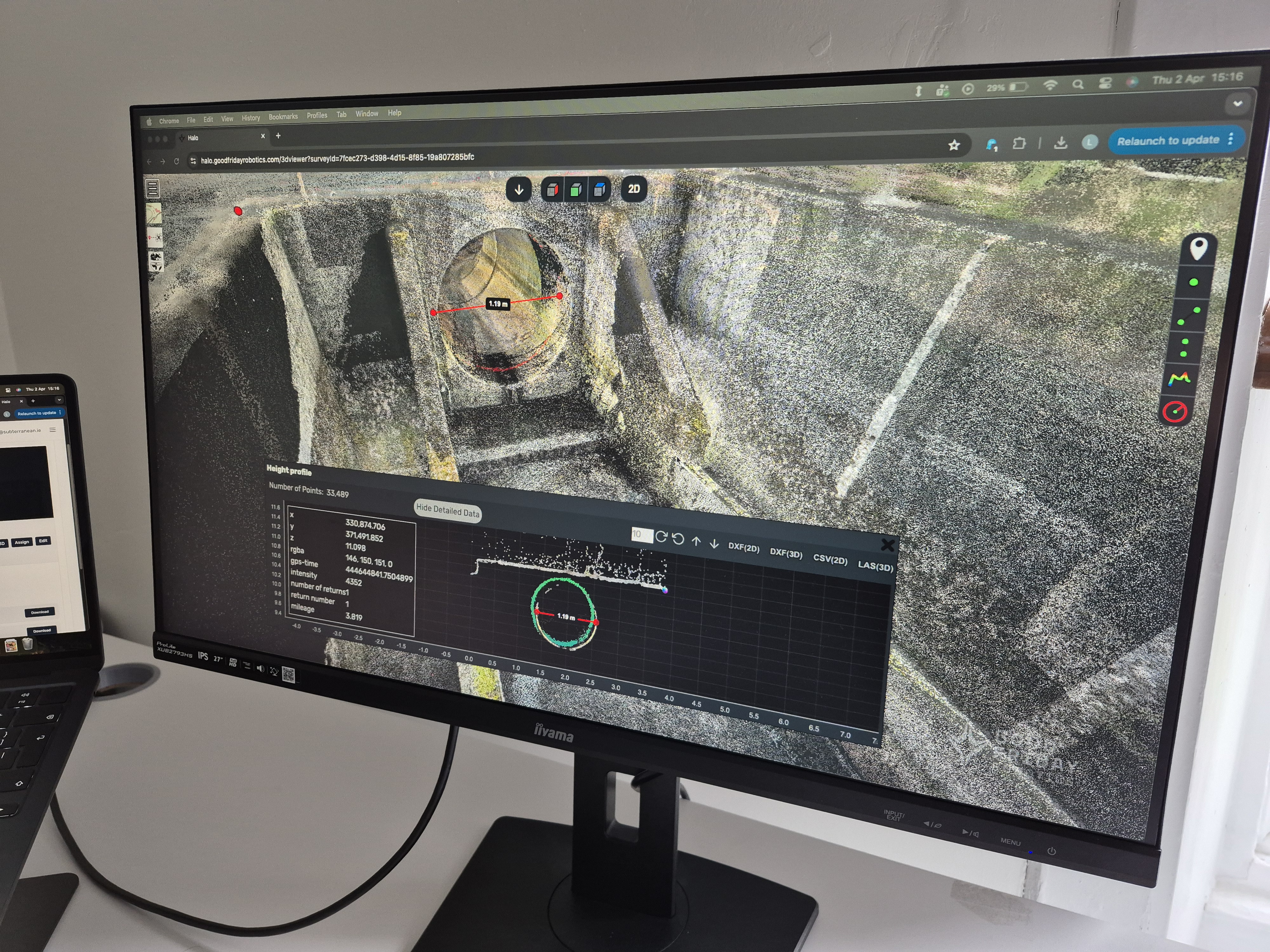
HALO is a spatial data platform that combines survey datasets into navigable 3D environments with integrated video context.
Who HALO Is For
UAV Operators
Conduct inspection flights in tunnels, pipes, and confined infrastructure.
→ Needs captured survey data presented as navigable, measurable 3D environments.
Infrastructure Managers
Responsible for maintaining, monitoring, and planning work on critical assets.
→ Needs spatial records that track condition changes over time to support maintenance decisions.
Survey Teams
Collect LiDAR, photogrammetry, and sensor data across multiple deployment sites.
→ Needs a single platform to integrate, manage, and share datasets across projects.
Capabilities
Survey Data Integration
Combine LiDAR, photogrammetry, and sensor datasets from multiple sources into a unified spatial environment.
Survey Data Management
Organise, version, and maintain structured records across projects and deployments for long-term infrastructure tracking.
3D Spatial Visualisation
Navigate complex 3D environments built from survey data. Inspect geometry, measure distances, and identify anomalies.
Integrated Video Context
Overlay inspection video onto spatial models. Correlate visual observations with precise coordinates in the 3D environment.
Environment Insights
Identify changes over time, assess structural conditions, and extract actionable information to support maintenance planning.
Collaborative Sharing
Share spatial datasets with stakeholders across teams. Export reports, annotations, and measurements for project documentation.
How It Works
From raw environment data to actionable outcomes in three steps.
Capture
Collect Survey Data
LiDAR point clouds, photogrammetry, video, and sensor readings are captured during inspection deployments.
Integrate
Build Spatial Models
Multiple data types are merged into navigable 3D environments with video overlays and spatial context.
Analyse
Extract Insight
Operators inspect, measure, compare, and track conditions over time — turning raw data into maintenance decisions.
Why We Built HALO
This product exists because conventional approaches fail in the environments where it matters most.
Environments are poorly mapped
Critical infrastructure exists in locations that are difficult to survey. Existing records are incomplete, outdated, or inaccessible — creating blind spots in maintenance planning.
Data lacks spatial context
Raw point clouds, imagery, and sensor readings are difficult to interpret in isolation. Without spatial integration, operators cannot connect observations to physical locations.
Decisions are incomplete
When data from different surveys cannot be compared or tracked over time, infrastructure managers lack the evidence to prioritise maintenance or justify intervention.
Part of a Larger System
HALO operates as one layer in an integrated stack. Each product strengthens the others.
LLRC-1
Feeds real-time video into HALO for spatial overlay and integrated visual context during inspections.
Learn more →Radio Visualiser
Monitors the network carrying survey data. Ensures reliable data transfer from deployment environments back to HALO.
Learn more →Inspection Services
Deployments generate the survey data that HALO integrates. Every inspection produces spatial records for ongoing analysis.
Learn more →Deployed With
"Subterranean has really helped us to achieve predictable and controllable flights in really tough conditions"
"Subterranean provides us with accurate survey data that has enabled us to deliver a reliable inspection service for our customers"
"Subterranean enables us to understand the condition of our Victorian-era sewer system so we can deliver reliable services for our customers"
See HALO in Action
Talk to our team about how HALO integrates with your inspection workflows, or download the technical datasheet.